Prepper › Handbook › Situation layers
Situation layers
🌐Situation layers
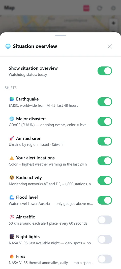
What is happening right now, as layers on the map. Each layer can be switched separately.
- Your alert places: colour = highest weather warning of the last 24 hours.
- Earthquakes: EMSC, worldwide from magnitude 4.5, last 48 hours.
- Major disasters: GDACS (EU/UN), ongoing events, colour = level.
- Air raid alerts: Ukraine by region, Israel, Taiwan.
- Radiation: Austrian and German networks, about 1,800 stations, red = elevated.
- River levels: Lower Austria, only gauges above mean water.
- Air traffic: aircraft around your alert places.
- Night lights: NASA satellite, last night. Dark patches = power outage.
- Fires: NASA thermal anomalies. Persistent spots are usually industry (cement, steel), not fires. Tapping shows a hint.
Which layers are offered depends on your region: river levels and radiation only exist where a network is connected.
What you use the situation layers for
Before a decision, the situation layers answer one simple question: is something under way that affects me? Before a trip you check river levels and storms; on news of a distant power cut you look at the night lights. The picture refreshes every 5 minutes. The layers give you the overview, while push alerts come from the Alerts module.
What is on at the start
- On: earthquakes, major disasters, air raid alerts, your alert places, radiation and river levels.
- Off, switch on when needed: air traffic (50 km around each alert place, every 60 seconds), night lights and fires. The two satellite layers come straight from NASA and need a connection.
Reading the sources correctly
- Radiation: the gamma dose rate is measured in nSv/h, by the Austrian radiation early warning system (111 stations) and the German Federal Office for Radiation Protection (about 1,700 stations). Each station is judged against its own normal value: red from 500 nSv/h, or from 300 nSv/h if the reading is almost double what is usual there. A site with naturally high background therefore stays calm.
- Floods: river gauges are grouped in classes: above mean water, then HW1 (annual flood), HW5, HW30, HW100. Red from HW5.
- Earthquakes: worldwide from magnitude 4.5 in the last 48 hours. Circle size shows strength.
- Night lights: dark patches can mean a power outage, but also cloud. A hint, not proof.
Limits
The data comes from measuring networks and agencies and is always a little older than the event. Without a connection the app shows the last known state. The situation layers do not replace an official warning. River levels and radiation only appear where a measuring network is connected.